|
|
|
|
|
|
|
LEA BRIDGE HALF LOCK and LOCK and POND LANE
* Not used except for water drawing
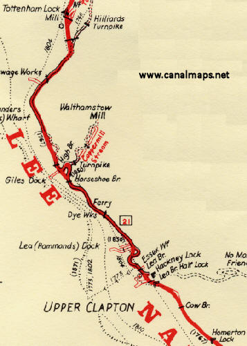
Below Tottenham Lock, the courses of the the Old Barge River and the Lee Navigation almost coincide until Lea Bridge is reached where they part company again at the weir. This was originally the site of the Hackney Waterworks and its Tidal Pound Lock (built as the Lea’s third pound lock by 1762).
11.12.1762 "to appoint a proper person to open and shut the Lock or Cistern and fflodgate standing on the River near Hackney" (NA Rail 845/2)
At a meeting on 13th January 1768, the Trustees approved that Jeremiah Illsley of Hackney, Brickmaker, should dig “a navigable Cut from the River Lee near Hackney Waterworks into the same river near Old Ford” for “threepence a yard” (NA Rail 845/4)
The old course heads out to the east and then turns south-east and south to rejoin the Navigation below Old Ford Lock. The Hackney or Homerton Cut was built in 1769 to bypass this wandering route. Just below the junction was the Lea Bridge Half Lock.
9.10.1772 “A lock house be built at Lee Bridge for £49” (NA Rail 845/4)
On 12.1.1780 it was “Resolved that the following Locks be repaired with all convenient speed Viz. … Lee Bridge Half Lock, Hackney Marsh Brick Cistern Lock And It Is Ordered that the Surveyor do repair the same as he shall find them absolutely necessary” (NA Rail 845/5).
20.11.1793 “A Lock with double gates be put down at Lee Bridge instead of the single pair of Gates now there.”( NA Rail 845/7)
In 1850 the lock was taken out of use and removed.
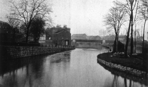
View from the former site of Lea Bridge Half Lock towards Lea Bridge Road. The weir lies to the right behind the trees.
20.4.1894. “at the North London Police Court on the 14th Instant, James Kits, of Bromley was fined ten shillings and two shillings costs, for navigating a steam launch at Lee Bridge beyond the rate of speed prescribed by the Bye Laws” (NA Rail 845/27)
28.6.1895. “at the North London Police Court on the 20th instant before Mr Paul Taylor, C Judd of Lee Bridge was fined 20/- and 2/- costs, for navigating the “Clapton Belle” steam launch at a greater speed than that prescribed by the Bye Laws” (NA Rail 845/28)
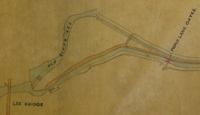
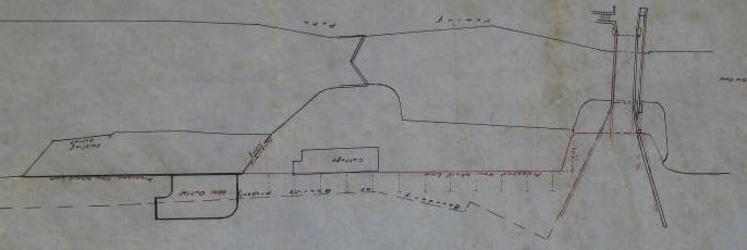
A plan dated shortly before August 1857 shows Lea Bridge Lock and Pond Lane Lock which was built at Cow Bridge.
LMA ACC 2423/P/457
LMA ACC 2423/P1435 dated 16th July 1863
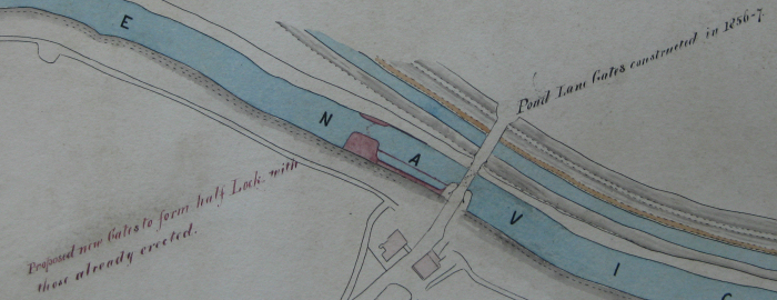
Nathaniel Beardmore's plan (in NA 845/15) that "the new gates shall be capable of holding up the entire Old Ford pond of water" and "to take pressure from both sides" to protect the Old Ford to Ducketts traffic from low water caused by the drawing of water at Lea Bridge" seems not to have been approved. When the extra gates were fitted between September and December 1863, they faced upstream and would not have prevented a back flow. Work was slightly delayed by the late arrival of the Granite coping and anchor stones from Cornwall.(NA Rail 845/15)
The lock was redundant by 1872 when it was "all thrown into one level from Tottenham to Old Ford".
However the structure was retained as a flood relief measure and only removed when Pond Lane Flood Gates were built further upstream.
The building of the house at Pond Lane was authorised on 15.8.1863 (at the same time as the extra gates above) and on 20.4.1883, the house was insured for £150 (NA Rail 845/23) and on 16.10.1885 Mr J Child, the Engineer, reported that "new windows had been fixed in place of the old ones which were smashed during the time between one lockman leaving and the new one coming in..." (LMA ACC 2423/002)
14.6.1907 Comment from Annual Survey “Cottage in bad state by reason of dust, etc., from Hackney Borough Council Destructor Works” ( NA Rail 845/34)
This plan, dated 31.10.1928 records the removal of Pond Lane Lock. Old Ford is to the right of the plan
LMA ACC 2423/P2088
In 1930, the lock house was re-occupied by Board employees, when the Weir keeper at Lea Bridge took up residence there.
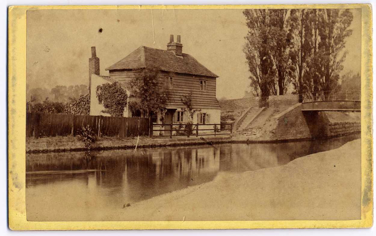
The Conservancy House at "Strongs Cottage" was located at the western end of Strong's Bridge, as shown in the image below. taken probably in the late 19th century.
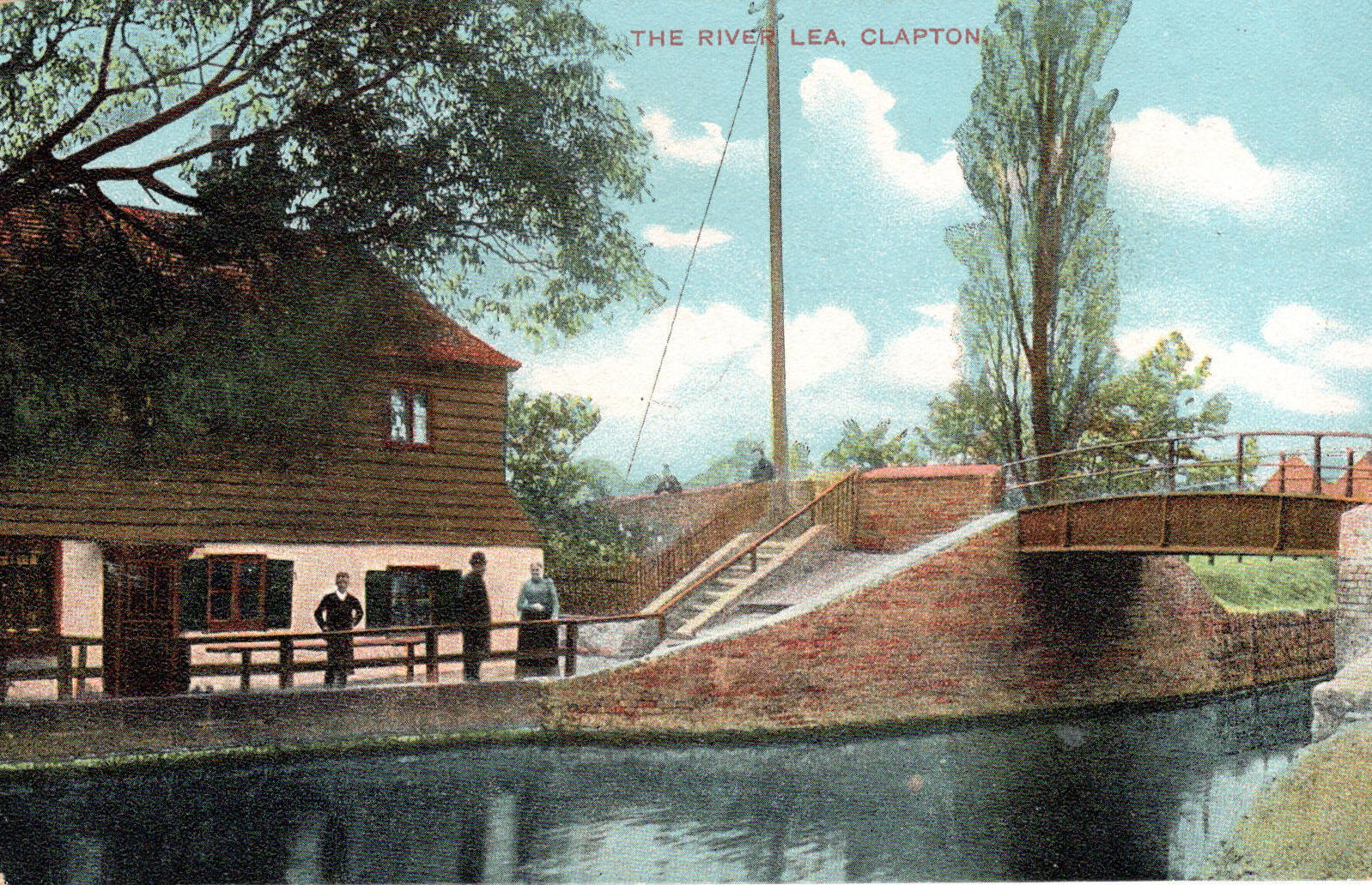
Hackney Archives P3051 The image below is one of several postcards of the bridge in my collection, this one posted on September 28th 1904 and possibly taken some fifteen years after the one above. The trees in front of the cottage have grown considerably and the tall trees to the right have been reduced to one.
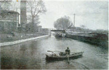
This next rather poor quality photo shows Strong's Bridge from upstream. The gable end of the cottage can be seen on the right. The building on the left is the Victoria Engine House, part of the waterworks. The chimney next to the building, is marked on the plan P2009 below.
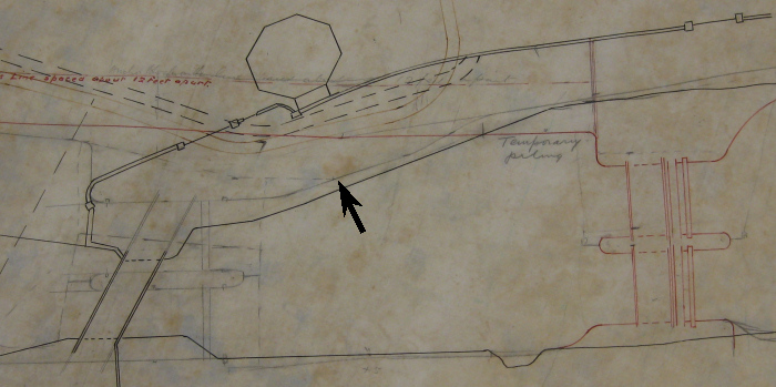
Pond Lane Flood Gates It is worth noting that the "Pond Lane" name, referring to the Flood Gates, has travelled (with the gates) some 500 yards upstream. The original flood control gates were sited as shown in the plans above. Pond Lane was the original name of the present Millfields Road. The name was changed in 1915. At the same time, Pond Lane Bridge became Cow Bridge. Pond Lane Flood Gates were built in 1931 to stop (among other things) the flooding of Hackney Marshes. They were sited just downstream of Strongs Bridge (which was removed when the gates were built) as can be seen from the plan below, although the river was not widened to the extent shown by the red line marked "Temporary piling" but to the faint black line indicated by the arrow
LMA ACC 2423/P2009
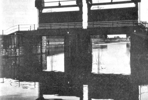
The flood gates at Pond Lane, viewed from the upstream side
18.1.1924: "This weir (Lea Bridge) is worked by Constable Fordham who resides in our cottage at the site of old Brick Lock, Homerton, and his services are mostly taken up with this duty, and as we are in need of another Police Constable to extend the Police patrols as far as Tottenham, I suggest we build a cottage on the site of Strong's cottage near the weir" Handwritten note "Agreed in principle" (LMA ACC 2423/021)
16.1.1926: It will be remembered that I reported upon the question of building a cottage on our vacant ground at Strong's cottage on January 18th, March 28th, April 11th and June 20th 1924. In my opinion it is quite necessary... (LMA ACC 2423/023)
Wikipedia's summary brings the story together very well! "The flood gates were the third water control structure to be built in the vicinity. When the Hackney Cut was first opened in 1769, the River Lea flowed over a weir, now known as the Middlesex Filter Beds Weir, to follow its original course, and the new cut was protected by Lea Bridge half lock, a single set of gates just below the start of the cut. These could be closed to prevent high levels on the river affecting the cut. Lea Bridge Lock was demolished in 1853, and was replaced by Pond Lane Lock at Cow Bridge in 1865, but it was only operational for seven years, as the navigation was rebuilt for larger barges, and was made level between Old Ford and Tottenham. Although the lock was no longer needed, it was retained so that it could be used to protect the cut from flooding as Lea Bridge half lock had once done. There were plans to fit it with gates pointing in both directions, to prevent draining of the cut below the gates if too much water was drawn from the river by the waterworks at Lea Bridge, but this was not carried out. The structure lasted until 1931, when it was demolished, to be replaced by the Pond Lane Flood Gates, a little further upstream. These consisted of vertical guillotine gates, which could be used to isolate the cut in times of flood, and were designed to help prevent flooding of Hackney Marsh. The construction of the Thames Barrier caused the flood gates to become redundant and they were finally removed in 1987"
There are separate census returns and Conservancy records for Pond Lane Lock. Pond Lane entries are included below but indicated. Lea Bridge Half Lock, Lea Bridge Lock, Pond Lane Lock and Lea Bridge Weir
|
|||||||||||||||||||||||||||||||||||||||||||||||||||||||||||||||||||||||||||||||||||||||||||||||||||||||||||||||||||||||||||||||||||||||||||||||||||||||||||||||||||||||||||||||||||||||||||||||||||||||||||||||||||||||||||||||||||||||||||||||||||||||||||||||||||||||||||||||||||||||||||||||||||||||||||||||||||||||||||||||||||||||||||||||||||||||||||||||||||||||||||||||||||||||||||||||||||||||||||||||||||||||||||||||||||||||||||||||||||||||||||||||||||||||||||||||||
This site was last updated 13-May-2021