|
| |
|
|
|
|
There are multiple streams which, combined with the natural and original course of the River Lea, form the basis of the waterways on which the Gunpowder Mills were built. However, the origin of these waterways is shrouded in history. Are the Hooks Marsh, Horsemill, Millhead and Cornmill Streams man-made or, like the River Lea, natural?
Alfred the Great had agreed with the Danes that the Lea should be the southern part of the boundary between Wessex and the Danelaw. In 895 the Danes transgressed this agreement, sailed their fleet up the Lea, sacked the settlement at Ware and made camp there. There is an enduring legend that Alfred, in revenge, caused new channels to be dug that drained the upper reaches of the river and stranded the Danish fleet at Ware.
The earliest written contemporary history is the Anglo Saxon Chronicle, started on King Alfred’s orders in about 890. The Chronicle tells us “A .D. 896. ….Then, some day, rode the king up by the river; and observed a place where the river might be obstructed, so that they could not bring out their ships. And they did so. They wrought two works on the two sides of the river. And when they had begun the work, and encamped before it, then understood the army (the Danes) that they could not bring out their ships. Whereupon they left them, and went over land, till they came to Quatbridge (near Bridgnorth) by Severn”.
The report of the creation of two extra channels (rather than works) by Alfred’s men does not appear until Henry, Bishop of Huntingdon’s historical account, written in the mid 12th century. This late addition does throw doubt both on the accuracy of Henry’s version and the truth of the legend, though it does suggest that extra waterways were in existence by that date.
The Domesday Book reveals that in 1085, “there was one mill at the time (c1066)…now three”. Since the windmill did not arrive in England until the 12th Century, these mills must have been water powered. The length of the millstreams is a factor of the shallowness of the drop of the Lea Valley at this point. In order to obtain a good head of water here, a long pound above the mill is necessary.
Is there also an entirely “natural” origin for the multiple channels at Waltham Abbey? There is an established geological phenomenon called “braiding”. This occurs when the fall in a broad valley is slight and a single waterway splits, quite naturally, into a number of smaller channels. This suggests that some of the streams at least, could always (in geological terms) have been there.
There were three watermills in Waltham Holy Cross by 1085, before the establishment of the Abbey of Augustinian Canons by 1184, though it is true that Harold Godwinsson, later King Harold II, founded a college of secular canons at Waltham Holy Cross in 1060. The local legend that “the monks built the Cornmill Stream” must be a possibility, as it is likely that the canons built their own mill on the edge of the Abbey grounds. Archaeology has revealed that there was a lower stream powering one of the Abbey millwheels. The Cornmill Stream was surveyed and built up higher along the eastern side of the valley to give a sufficient head of water not only to drive the mill wheels but also to provide running water within the Abbey for sanitary purposes. The Millhead Stream has also been artificially raised above the natural fall of the valley to provide a head of water at its southern outfall.
The earliest surviving map of the area is held in the archives of Lord Salisbury at Hatfield House. This map gives us a portrayal of the waterways at Waltham Abbey in 1590.
Comparison of the 1590 map with J Parker’s Barge River map of 1767, held at Northampton Record Office, and a modern interpretation of the waterways as they were in 1827, at first suggests that the 1590 map has an extra channel (D), which does not exist today.
However, if the various streams are identified, it is possible for all three maps to agree. A – The Corn Mill Stream B – The River Lea Barge River C – The Millhead or Powdermill Stream or River D – The combined Hooks Marsh Ditch and Horsemill Stream (not shown on Parker’s map)
On the 1590 map, a Fulling Mill is marked in the same position as the Powder Mills on the 1767 version on Powder Mill River (C). It was on this site that the present Gunpowder Mills started. It is known that there were powder mills near Hooks Marsh in 1672-3, though these were fairly short-lived and had gone by 1735. Hooks Marsh is just to the north of the present Gunpowder Mills site.
A fulling mill uses water power in a process in clothmaking which involves the cleansing of cloth (particularly wool) to get rid of oils, dirt, and other impurities and to spread and tighten the fibres to thicken the material. In the early 17th century this Fulling Mill was converted to an oil mill. Then a deed of 1669 tells us that the “Oyle Mill…now lately converted into two powder mills...for the grindinge, boylinge, corninge and drying of powder”
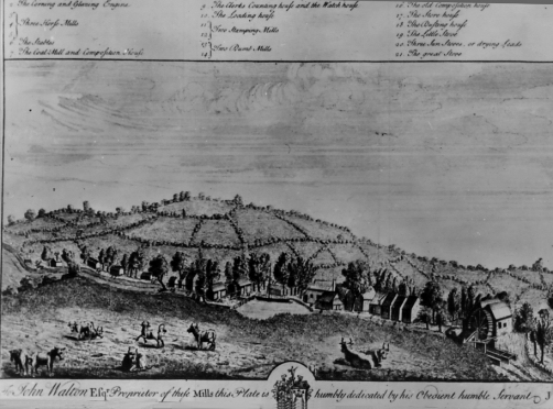
In 1735, forty-five years before Mr Parker drew his map, Mr J. Farmer produced his detailed view of the Powder Mills and humbly dedicated them “To John Walton Esqr. Proprietor of these Mills”.
This clearly shows the Millhead stream (from left to centre) powering not only the two stamping Mills (centre, one each side of the Millhead) but also a number of other water-powered mills above. It appears that the tail stream of the upper mills also powers a further large corning and glazing mill, (this was possibly the mill that blew up in 1781 with the loss of “three men killed and much damage done in the town”). In 1770, Peter Muilman wrote, in his New and Complete History of Essex of the factory of “several curious gunpowder mills, on a new design, worked by water (the old ones having been worked by horses)”
But first, consider the reasons for using water to carry the sometimes sensitive loads that needed to be transported between process buildings. As can be seen from Farmer’s drawing above, as early as 1735, buildings were spaced out to leave gaps between them. However, without the protection afforded by earth traverses, which did not appear until the late 18th century, there could still have been chain reaction and sympathetic detonations if a building exploded. The answer was to put even more space between them. The communication between the buildings was thereby extended. Water would have provided a much smoother passage than the rudimentary unsurfaced tracks that were the norm in those days. |
This site was last updated 02-Aug-2014