|
| |
|
|
The First Period. Up to 1750 The date when the Lea was first navigated is lost in the mists of pre-documentary history. Nevertheless, as on many rivers, early man must soon have realised the value of using the natural stream for transporting himself and his goods and for protection against his enemies. This is exemplified in the Lea valley by the evidence of lake dwellings created by a middle to late Bronze Age community and an associated dug-out canoe in the Walthamstow marshes; while in the same marshes there has recently been found the remains of a Saxon boat 13 feet long and dating from between A.D. 950 and 1000.6 While the activities of Bronze Age man indicate a developing structural ingenuity they were clearly limited in scale; but in the Saxon era skills more technically advanced are demonstrated in the construction and utilisation of leats, channels and weirs to obtain the necessary power in the headraces for the watermills referred to in Domesday Book. A case in point here is the construction of the Saxon Cheshunt Mill and its watercourse which caused problems nearly a thousand years later following improvements made to the navigation in the 1770s and which still cause difficulties today despite the fact that the mill was demolished nearly 200 years ago and the site today is a gravel pit. Cheshunt is by no means the only mill in the Lea valley mentioned in Domesday Book and some of the mill leats constructed by those early unknown engineers formed the basis centuries later for improvements to the navigation by increasing the cross-section of the leats to provide a navigational channel in a more direct line than the meanderings of the natural river. These early mills, too, provided the traffic carried on the navigation, though there was a love-hate relationship between the millers who wanted the water to power their wheels and the bargemen who wanted the water to carry their boats over the shoals in the poorly dredged river. The earliest documentary reference to the Lea is of an engineering nature albeit a military one, though again anonymity reigns over who did the work. It is recorded that when the Danes were invading England they sailed up the Lea and while they were encamped in the valley King Alfred had channels dug to drain off the water more quickly thus causing the Danish fleet to be stranded and the troops had to retreat overland to the west. The site of the strategem has never been positively identified but the circumstances are quoted in the Anglo-Saxon Chronicles, admittedly written some time after the event. Firmer evidence of engineering activity is given in the first contemporary written record. This is a licence granted to the Abbot of Waltham Abbey on 9 September 1190. Translated from the original Latin it reads: W (presumably William Longchamp) by the Grace of God, Bishop of Ely and Chancellor of the Lord King, to the Sheriff of Essex: Know that we have given permission to the Abbot of Waltham to turn aside the course of the water of the Lea in the Town of Waltham as he wishes without harming anyone and for the advantage of navigation and therefore we order you to allow him to do this without impediment.7 Just what this involved is unknown but it is probable that it was to straighten the course of the river by removing some of the meanders. There has been so much alteration in the Waltham Abbey area that any improvement 900 years ago has long since disappeared. Waltham Abbey figures, too, in the next engineering project for which there is a record. The abbot wanted an improved fresh water supply for the Abbey which lies to the east of the Lea. The finest sources were springs at Wormley on the west bank of the river and this meant piping the water across the Lea to the Abbey. The pipe was almost certainly composed of longitudinally bored tree trunks sharpened at one end and hollowed at the other so that with the joints sealed by a fillet of clay they would form a continuous pipe. In crossing the river the method adopted is clearly given in a document of 1221: They reached the great river with the water pipe ... In the morrow of the decollation of Saint John (30 August 1221) they dug a ditch in the bottom of the great river transversely to a depth of two feet more than in the neighbouring land and in this they placed a long and strong pipe stretching beyond the river ... they strengthened it and made it safe lest the pipe should be harmed in any way by the oars or poles of the watermen passing.8 This practice foreshadows techniques used in taking pipes across rivers which have been adopted right to the present day. During the 14th century there are frequent reports of further mill leats being constructed, weirs installed, and bridges being erected and repaired on the river. For example: The prior of St Bartholomew of West Smithfield, London, has a mill at le Eldeford (Old Ford) the lock whereof is too narrow by a foot and a half and the threshold of the lock is too high by a foot and a half; the lock should be open from the Annunciation to St Peter's Chains as was the custom in ancient times. The abbot of Stratford has made a barrier of piles at `le Leymouth' in midstream 10 perches long from his land to the king's highway, very greatly impeding the watercourse, so that neither fish nor boats can pass.9 On 10 April 1380 a Commission of Oyer and Terminer was issued to various persons "to examine defects in the river and which ought to be repaired by the Constable of the Tower of London and also examine the weirs, mills, etc.” 10 It was in 1424 that a more positive step was taken to improve the Lea which again demonstrated that although the will was there the practicalities were rather more uncertain. This was an Act of Henry VI giving power to the Chancellor to enquire into and amend defaults caused by weirs, mills, etc, and further Acts of 1425 and 1430 empowered commissioners “to remove shoals or sandbanks from the bed of the river and thus eliminate obstructive shallows." In referring to mills it could easily be assumed that they were corn mills following the traditional operations of producing flour and meal and while many of the mills on the Lea and its tributaries were indeed corn mills, other industries were using the water power available. It is here that the expanding engineering and technical knowledge introduced by individual entrepreneurs can be seen to extend beyond, yet remain dependent on, navigational and construction expertise. Fulling mills had early been established in the lower Lea valley to mechanise the felting process previously performed by treading or "walking" the woollen cloth, just as such mills could be found in other parts of the country. At the end of the fifteenth century a completely new industry to Britain appeared in the Lea valley at Hertford. This was the first paper mill to be established in the country. Started by JohnTate in an existing mill on the River Beane near its confluence with the Lea, it was in operation in 1494, and possibly before this date, but had ceased probably by Tate's death in 1507. There could have been various reasons for its failure, although competition from the continent undoubtedly played its part. Nevertheless it supplied paper for Caxton's printing press. The value of its site is well summarised by Dr Hills: "So the site chosen by Tate would seem to have had suitable water for papermaking; adequate provision for power; good transport facilities near by, and been close to London from where its raw material, rags, would have come and where the paper would have been sold." Henry VII himself visited there in 1498 and gave a reward to "Tate of the paper MyIne".12 Two hundred years later paper was again being made at watermills in the Lea valley at Tottenham and Walthamstow. Another industry which benefited from its proximity to London, the rural nature of the Lea valley, the power from the water, and the suitability of water transport was that of gunpowder manufacture. The earliest sites were in the Stratford area where powder was certainly being produced in the 1580s and 1590s but after the abolition of monopolies of saltpetre and gunpowder in 1641 other mills in the valley were producing gunpowder - Enfield, Tottenham, Walthamstow, Leyton, Sewardstone and Waltham Abbey where explosives production continued into the late twentieth century.13 In the early part of the sixteenth century little progress was made on improvements to the navigation but in 1574-1577 came a momentous engineering event. Centuries before, China had seen the construction of pound locks on inland waterways - that is chambers "deep as the home of a sleeping black dragon" with gates at each end and into which water could be admitted or from which water could be withdrawn so as to raise or lower a boat from one level to another.14 This concept only reached England with the construction of a lock on the Exeter Canal between 1564 and 1567 to afford a link between the tidal estuary and the canal. Prior to this and subsequently on certain rivers until the present century changes in level were accommodated by flash locks, otherwise known as turnpikes, whereby water was penned back, and then when the gate was opened the water cascaded in a flood carrying the boats over the shallows below. This was tremendously wasteful of water and it is obvious why the millers objected to allowing boats to pass when milling was in progress. In 1571 an Act was passed to construct a canal from the Lea to London under the authority of the City of London but, though no work was carried out, a Commission of Sewers in 1574 authorised certain improvements on the Lea.15 These included a pound lock at Waltham Abbey - the first pound lock to be constructed on an inland navigation in this country and which was completed in 1577. Fortunately schedules and specifications of the materials to be used in the building of the lock have survived and it has been possible to re-establish the whole design. It was of timber construction approximately 70 feet long by 22 feet wide and a complete depth of 10 feet though it is not clear what the actual change in level occurred between the water above and that below the lock. Regrettably also no indication is given on how the gates were operated nor on the paddle gear for filling and emptying the lock.16 Within two years there had to be a complete reconstruction due to settlement and a masonry base was provided. Its novelty attracted interest but the constant alternate exposure of the timbers to air and water led to decay and in 1590 William Vallans could write in his "Tale of Two Swannes": Among them all rare devise they see But newly made, a waterworke, the locke Through which the boates of Ware doe passe with malt. This locke containes two double doores of wood Within the same a cisterne all of Plancke Which only fills when boates come there to passe By opening of these mightie doores with sleight And strange devise, but now decayed sore. Its site was not on the present navigation but on a new channel linking the mill head to the old River Lea thus bypassing the mill. Violent opposition to the use of this lock for improving the navigation came from the "badgers", the land carriers of the malt, transporting it on packhorses. They allied themselves with Sir William Denny the owner of the turnpike on the Corn Mill Stream. The result was that after several attacks the lock was completely destroyed in 1592 and was never rebuilt. Nevertheless the episode reveals the concern for technical improvement of the navigation. Meanwhile the growth of London was making other demands on the Lea Valley apart from power supplies for mills and facilities for improved navigation. London's water supply was still, as it had been for centuries, dependent on springs, wells and the polluted waters of the Thames. By the end of the sixteenth century an augmented and consistent supply was vitally necessary. 30,000 people had died of the plague in London in 1603 and one cause of the disease was "the fowle and unsavory ditches". In 1604, Edmund Colthurst, who had been agitating for power to bring a fresh water supply from Hertfordshire for many years was granted Letters Patent, but the prime mover in the enterprise became Hugh Myddelton. The proposal was to bring water from springs at Chadwell between Hertford and Ware by an open channel into London. On 29 September 1613 this 40 mile channel, later to be known as tile New River, was opened from Chadwell Springs to New River Head, Sadlers Wells, Finsbury.17 It was a remarkable engineering feat for its time and demonstrates that an accurate system of levelling had been able to create a constant fall of approximately 5.5 inches to the mile or less than 20 feet in 40 miles where the distance as the crow flies is approximately 24 miles. Its impact on the Lea, the milling community, and the bargemen was not immediate as the demand from Londoners for the New River water was limited and the supply was adequate. By 1620, as appreciation of the quality grew, demand increased. In order to augment the flow the New River Company built a dam in the Lea to divert water into Chadwell basin.18 This promptly drew protests from the millers and the bargemen, the former complaining that their head waters were down and they had inadequate power for their wheels; while the bargemen alleged that the level of the river was lowered so that their boats were landed up on the shoals and shallows. Arguments continued into the Restoration period until in 1670 a committee of investigation, which included Christopher Wren, showed that the amount extracted by the NRC pipes "drew off from the navigable river about one part of thirty parts, which appeared to us very little prejudicial to navigation and which could not abate the river half an inch".19 The 1670 committee carefully considered the claims of the three groups, the bargemen, the millers and the NRC, and concluded that the activities of all three were vital to the welfare of London. With the wisdom of Solomon they recommended that the NRC should be limited to its existing out-take; that the millers be regulated both as to the size of their wheels and the price to be charged to the bargemen for flashes; and for the Lea: “When all this is done the Lea cannot be made complete for navigation without some expense be laid out upon it by Act of Parliament in order to cut other channels, to buy out some mills and such other things as are or would in foreign parts be put in practice for the public benefit.” With the NRC still taking water through the two pipes, disputes and legal actions continued and the complaints were not satisfied. In due course a more formal agreement was reached whereby the NRC would measure more accurately the amount of water extracted through their out-take and an agreed figure would be paid to Hertford to assist in the maintenance of the navigation. But the whole problem had festered for 70 years before the final concord was ratified by an Act of Parliament in 1739 under which the River Lee Navigation Trust was established. In none of this were any engineers mentioned by name and therefore it has to be assumed that local people were employed as and when required. The more accurate arrangement mentioned above is described in a petition presented to Parliament in 1739 by Phillipa and John Walton, owners and occupiers of Waltham Abbey Gunpowder Mills, against the proposed Act. Their description is very full and indicates that whoever designed the "balance engine" was well-versed in hydraulics: “By the Bill the New River Company are to hold and enjoy a quantity of water issuing from the River Lee at or near the mouth of the Manifold Ditch through the Ballance Engine erected in 1733 by the Company which is to pass through the Manifold Ditch to the Company's sluice standing cross the Ditch near a small piece of land called Chalk Island and from the sluice along a trench made from thence into the New River through a trough lately placed there by the company which is of the clear dimensions of 6 feet in breadth, 2 feet in depth, and 14 in length. The quantity of water will furnish 2100 tuns an hour which is 50,400 tuns in 24 hours and will not fall back into the Lee whereas by an Order in Council made in Charles the Second's reign the New River Company were allowed two pipes, one 6 inches diameter and one 8 inches diameter yielding 200 tuns an hour. The Ballance Engine is so artfully contrived as to draw as much water out of the river when the water is at the lowest as it does or can do when it is at the highest by a ballance boat which sinks as the water falls and so in course raises the gate of the sluice so much higher which by that means is always capable of supplying the lower gage erected near the turnpike in the old Barge river which is the trough of the above dimensions which is constantly full and as the water rises in the river it lowers the gate of the sluice to such a degree as to prevent more water going down than can run through the gage which is so exactly calculated as to keep the New River at all times brimful: for if it was to receive more water it must either be let out again or would overflow the meadows.” 20 This balance engine is referred to in Section 5 of the 1739 Act but is not specifically described. However after it was dismantled the Metropolitan Water Board mentioned it in their 1925-1926 Annual Report: “The floating gauge has been dismantled, but it is of great historic interest as one of the oldest methods of measuring the flow of water. A sluice gate was attached to a large oak beam and to the other end of the beam a boat was suspended which rose and fell with the height of the river thus allowing a greater or less volume of water to flow through the sluice.” With the establishment of the Trust a more formal control over the navigation came into being yet despite an all-embracing list of Trustees nominated in the Act few ever took an interest in the well-being of the navigation. Those who did laid the foundations for a greatly improved organisation. At the first meeting on 6 August 1739 a Clerk and a Treasurer were appointed, but no Surveyor or Engineer. The Trustees decided to apply for a Commission of Sewers for scouring, cleansing and preserving the Lee. A month later a committee was appointed to view the river and to call for evidence from artificers, bargemasters and navigators and on 28 September they employed William Whittenbury of Hertford to take levels between Hertford and Ware. The choice fell on him as he had been employed in 1733 to make a map of the river between these two places. Whittenbury is described as a carpenter and joiner, but clearly he must have been a master craftsman.21
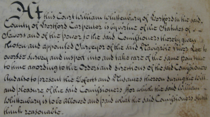
NA Rail 845/53 This is an extract from the Records of the Justices and Commissioners of Sewers dated 11th July 1740. The text is "At this Court William Whittenbury of Hertford in the said County of Hertford Carpenter is by virtue of the Statutes of Sewers and of the power to the said Commissioners thereby given chosen and appointed Surveyor of the said Navigable River Lee to oversee survey and inspect into and take care of the same from time to time according to the Orders and directions of the said Commissioners. And also to present the Defects and Nuisances thereon during the will and pleasure of the said Commissioners ffor which the said William Whittenbury is to be allowed and paid what the said Commissioners shall think reasonable." As a result of Whittenbury's survey the Trustees advertised for plans and tenders to construct a turnpike on this stretch of the river. Only two tenders were submitted, one from Whittenbury; and the other from John Kirby of Hertford, bricklayer. The latter's estimate was so defective that he was asked to resubmit. At the resumed consideration Whittenbury's tender of £273 was accepted against John Kirby's of £390. It is interesting that they both agreed each other's tenders. Whittenbury thereafter was regularly employed on a contract basis and undertook a number of important improvement schemes. He died in 1757. Although John Clark was appointed as Whittenbury's successor he does not appear to have carried out any major works. It was at this period that the Trustees started looking to national figures for advice on improvements and for guidance on the content of a more comprehensive Act. This leads directly on to the second period of engineering in the Lea valley. |
This site was last updated 16/09/09