|
| |
|
|
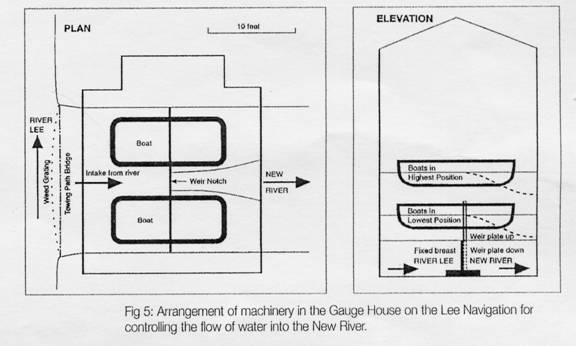
The Second Period: 1750-1850 The Trust which had been formed under the 1739 Act was formally empowered to appoint new Trustees to replace those who had retired or died but this power had rarely been exercised except in 1757 when 22 new Trustees were appointed. Because of this, meeting after meeting had been adjourned as a quorum had failed to attend for several years. Furthermore, it was evident that the powers of the Trustees to effect improvements to the navigation, particularly in the lower reaches, were very circumscribed and its general state was steadily deteriorating so much so that in 1760 malt intended to be transported to London by barge was being sent by road from the wharves at Ware. As a step to improving conditions Thomas Yeoman was appointed as Surveyor. Yeoman was an experienced engineer and in 1771 became the first President of the Smeatonian Society of Engineers. He was also a Fellow of the Royal Society, as was John Smeaton who in 1759 was invited to prepare a report on the condition of the Lee Navigation and to advise on engineering work "to remove the defects prejudicial to its efficient operation". There is no indication in the minutes as to whether Smeaton accepted at that time but a survey was carried out by Yeoman and Joseph Nickalls in 1762, though no action appears to have been taken on the report. However, on 5 August 1765 the Trustees: “took into consideration the state of the navigation and resolved to have the navigation settled (if they can) on such a new plan as will be most conducive to the good of the public and ordered their Clerk to apply to Mr Smeaton to take a survey of the river and prepare a proper plan for them to proceed on for carrying their resolution into execution.” The minutes are again silent for nearly twelve months until 16 July 1766 when: “... the Trustees after taking into consideration the state of the navigation did order Mr John Smeaton forthwith to take a survey and make a plan and estimation of the best method of making a navigation from Hertford to the River Thames and that Mr Thomas Yeoman should assist John Smeaton therein and that John Smeaton make his report to the Trustees on or before 29 September next and the Trustees ... desire ... Smeaton to be as particular as he can in the description of such parts of the course of the intended navigation where he shall be of opinion that new cuts ought to be made and what effects such new cuts will have upon the land they shall respectively pass through and the mills and other estates adjacent.” This was clearly a very peremptory demand on the leading civil engineer in the country at this time and on engineers who were not employed full time by the Trustees. It indicates a changing emphasis in the relationship between the Trustees and their consultants. In response to these demands Yeoman presented Smeaton's report to the Trustees on 30 September 1766. It is interesting that there is no entry in the minutes as to the fees to be paid to Smeaton nor is there any mention of Smeaton having attended before a meeting of the Board. The only mention of Smeaton's name subsequently is when Yeoman suggests modifications of the plan. Nevertheless the report was fully accepted by the Trustees and it formed the basis on which the Trust went to Parliament with Smeaton's finalised estimate dated 26th February, 1767 and obtained the 1767 Act.22 This provided the legal authority for the new cuts and improvements which were made in the late 1760s and 1770s largely under the guidance of Yeoman.. However, Yeoman, while appointed as the Lee Trustees' surveyor, was also advising the undertakers of the River Stort Navigation between 1766 and 1769 and on its opening on 24 October 1769 proudly announced: "Now is Bishops Stortford open to all the ports of the world".23 He might have added "via the Lee Navigation". In addition among other works he reported on the Forth and Clyde Canal in September 1769; acted as consulting engineer on the Coventry Canal, and prepared estimates for the proposed Leeds and Selby Canal in 1773. But to return to Smeaton's report. After commenting on the defective state of the navigation despite "the many attempts that have been made to improve its present principles" he offered three options based on the survey he had made with Yeoman in July 1766; firstly, the best scheme; secondly, the most frugal scheme; and thirdly, a medium between the two extremes which he recommended. He based his proposals on certain principles which included providing a minimum depth in the driest seasons of three feet in general and at least two feet six inches at fords; straightening the course of the navigation and making cuts; and providing locks instead of flashes to benefit the mills and to enable a vessel to travel from Bow Bridge to Hertford in about 13 hours. He also assured the Trustees that those matters which could not be included in the survey: “…will be properly enquired into and represented by Mr Yeoman; that is ... if any of the three schemes ... be carried into execution it will then be proper that Mr Yeoman be immediately employed to look over the grounds where the works relative to such scheme are to be created and as he is a judge thereof, which I am not, to estimate the probable value.” Smeaton was clearly confident in Yeoman's ability and this is demonstrated in the following paragraph of the report: “On a re-inspection of the plan it seems very desirable that a cutt should be carried from the Four Mills at Bromley to the Thames at Limehouse Hole, and which from a general knowledge of the ground I believe very practical; yet as this thought did not occur to me till I was completing the plan I must refer the gentlemen to Mr Yeoman's report thereupon; to whom the same thought occurred and who has viewed and levelled the ground, and which I shall further inspect when I come to town, if thought eligible.” The estimate for Limehouse Cut was £2497 which was in addition to each of the three estimates for the main navigation. These were £29,157-7-0; £24,103-15-0; and £26,652-18-0. In the event no one estimate was accepted in toto and the result was a composite plan of which the main features including the construction of Limehouse Cut and twelve other cuts were embodied in the 1767 Act. During the late 1760s and early 1770s the approved cuts were constructed by contractors working under Yeoman's supervision. These included the Limehouse Cut opened in July 1770. John Smeaton continued to act as a surveyor (possibly in a "private" capacity, being commissioned to investigate particular problems by various people. His reports on the following are all available: Situation of the Mills and Bleach-Field at Waltham Abbey, May 16th, 1767 On Waltham Abbey Powder-Mills respecting Navigation on the River Lea, March 27th, 1771 New River Works and Improvements, July 18th, 1781 Sewardston Mill, loss sustained by an alteration at Enfield Lock, November 12th, 1782 Loss of Grinding at Tottenham Mills, November 12th, 1782 Thomas Yeoman died in 1781 but had ceased to act for the Trustees in the late 1770s. In 1779 Robert Whitworth had been asked to act as a surveyor, though rather as a consultant than a full time employee. Whitworth was also a well-known canal engineer and he is later and more accurately described in the minutes as engineer - an indication that this term was coming into use. The duties of the surveyor set out in the minutes were far more concerned with toll collection and general oversight of the navigation than civil engineering matters. This differentiation is emphasised by the new appointments as surveyor. Benjamin Lewis held the post briefly until November 1779. On 22.12.1779 John Glynn of Bishops Stortford, a craftsman, was appointed at £120 a year. Benjamin Lewis was paid 10/6d a day "for attending Mr Glynn... to explain and show to him the whole Navigation". John Glynn was followed after his death (minuted on 25.8.1784) by his son, also John Glynn. An interesting side note in the Minutes at this time "Resolution that the Surveyor do not carry on any Business except....Surveying", perhaps implying that the Trustees wanted a man who would devote his attention solely to the Navigation. On 10.9.1784, the Trustees appointed "John Glyn of Bishops Stortford Carpenter....in the room of his Father John Glyn deceased...he be allowed a salary of two hundred Pounds a year" John Glynn, the son, left because of ill health in 1791. The new surveyor was James Griggs who had been the yard foreman. There is no suggestion in the minutes that he was expected to initiate new engineering works and in fact for the next few years little new work was undertaken. An interesting development occurred in 1803 which, though not initiated by the Trustees, their agreement, perhaps reluctantly, would have had to be obtained. Britain was at war with France and the success of Napoleon in Europe together with known preparations for invasion along the French coast had led to defence measures being taken along the south and east coasts by the erection of Martello Towers and by the construction of the Royal Military Canal in Kent and Sussex. The Supreme Command also considered the possibility of an attack being launched from the Low Countries on the flat lands of the Essex and Suffolk coasts followed by a drive westwards against London. In this terrain there are no natural defence barriers until the Lea valley is reached. Even these are not great and in order to strengthen them the Supreme Command considered the feasibility of flooding the whole of the Lea valley. On 15 July 1803, HRH the Duke of York, Commander-in-Chief, asked for a. report as to the practicability of this scheme. John Rennie was instructed to carry out a survey. This was later referred to by Lord Cathcart as "A report ... accordingly most expeditiously made by that very able engineer ..."24 Coincidentally Rennie was also carrying out a survey of tile navigation requested by the Trustees on 28 April 1803 but there is no suggestion that Rennie was selected by tile Army because of his presence in the Lea valley or because of his knowledge of the area. Rennie pointed out that the valley had a very gradual fall and although flooding did naturally occur from time to time it would be necessary to build dams at intervals along the valley to obtain flooding in normal weather conditions. The water would be deepest at each dam and the time of filling would be proportional to the distance the dams were apart. He therefore suggested it would be preferable to have lower dams and more of them. He went on: “A consideration of material consequence, namely that as each dam must be defended against the enemy the more dams, of course, the more men will be wanted to defend them - on this point I must beg leave to decline to give an opinion, it being more in your Lordship's province than mine.” He then proposed 14 dams including one at Waltham Abbey which would have flooded the Powder mills, one of the main sources of gunpowder for the forces, though this was not mentioned in the report. A further pertinent comment was: “To get two Feet of water in the shallowest places will take 90 days or three months in ordinary times and less in flood, but the enemy could cut the banks and the whole would be drained in a short time ... If therefore I may take the liberty to give an opinion I have my doubts whether it would be worth the attention of the Government to expend so large a sum of money (£20,000) as this will cost without any certain benefits to be derived from it towards the defence of the Metropolis.” Despite Rennie's reservations the Duke of York decided that measures should be taken and Samuel Wyatt contracted to do the work. Dams were constructed under the bridges on the Essex Road at Stratford and a dam with a floating barrier consisting of an old lighter acquired from the Navy was partially constructed in Bow Creek. By 28 October 1803 Rennie wrote to the Duke of York complaining that the works were not as forward as he would have liked but urgency was apparently not pressed because the work was still progressing four years later. By 1810 the military situation on the continent had radically changed while the limited amount of work done on the dams was already decaying and virtually useless. The whole scheme was then abandoned and no evidence survives today.25 Rennie continued as consulting engineer to the Trustees while the distinction between engineer and surveyor was becoming more fully defined. On 12 June 1823 in specifying the duties of the surveyor the first qualification detailed was that he should be well acquainted with the trade of carpenter and bricklayer. No major engineering works seem to have been required in the early part of the nineteenth century although Francis Giles was asked to make a survey in 1844 but this was never completed owing to his death. Because of problems with the water companies another important engineer, J M Rendel was appointed on 21 December 1847 under the following resolution: “Resolved that it be not desirable to suspend operations to ascertain our precise rights in respect of the Compensation Reservoirs belonging to the East London Waterworks, with this view and to assist Mr Griggs (the surveyor) in obtaining the desired information it is desirable to call in the assistance of Mr Rendel, the eminent engineer, now very much consulted by the Government and that he be employed accordingly.” Rendel was instructed to survey the navigation and negotiated with the East London Water Company on behalf of the Trust. The Trust's solicitor also advised obtaining evidence from G P Bidder on some of the engineering matters under consideration. In the 1850s the long-running saga of disputes between the Trust and the New River Company over the gauging of water from the river, despite the agreement which led to the 1739 Act, was again a matter of concern. Under Section 9 of the River Lea Water Act, 1855, the whole of the water flowing into and down the Lea and the Lee Navigation was vested in the water companies except that required for navigation. But the maximum the New River Company could take was limited under the Act to 2500 cubic feet per minute. 'The War Department also had an interest in this limitation because of their watermills and waterway system at Waltham Abbey and Enfield. To satisfy the stringent conditions a new gauge was constructed, still based on changing water levels but on a different principle from the 1733 gauge by controlling the water over a cill instead of through a sluice. This remains unique and demonstrates its effectiveness by still being in use today. Under the supervision of an engineer appointed by the War Department a building, looking from the outside like a house, was erected on the bank of the river between Hertford and Ware at the entrance of the take-off channel from the river leading to Chadwell Spring, the source of the New River. The ground "floor" of this house is water - essentially an extension of the water level of the river. Floating on the pool so formed were originally two cast iron boats 13 feet apart (these were modified in the 1970s) linked amidships by a segmental iron beam above the water. Directly below the beam and mounted on the bed of the channel is a submerged fixed weir plate six feet high. Rigidly suspended from the beam is a second weir plate which slides against the fixed plate to form a movable cill below the water surface. The movable plate being part of the framework attached to the boats moves up and down as the boats rise and fall thus allowing a constant depth of water of 16.5 inches to flow over the weir. This provides the water company with 22.5 million gallons per day. (Fig 5) The
movement of the weir plate is limited to 33 inches, ie: from 16.5 inches above to 16.5 inches below a fixed datum mark. Therefore as the water level varies between flood and drought conditions the water company receives a constant quantity. In excessive flood conditions a spillway south of the gauge house directs the surplus water into the Manifold Ditch and so back into the river below Ware lock. The growing importance of fully qualified engineers is reflected in the authority given on 20 November 1849 by the Trust to pay £1000 on account to J M Rendel and a further £1000 on 30 June 1850. These payments were part of the expenses involved in obtaining the River Lee Improvement Act which received the Royal Assent on 14 August 1850. From now on the Trust realised the value of having a qualified engineer more or less permanently associated with their affairs rather than calling on consultants on an ad hoc basis as the need arose. |
This site was last updated 02/08/14